
There have been many incidences in the recent past when India’s map has been inappropriately represented. Many platforms from Twitter to US dailies have misrepresented map of India. The recent guilty of showing a distorted map of India is the newspaper giant ‘Times of India’.
Read More- Calcutta HC warns Times of India against publishing misleading reports on Bengal post-poll violence
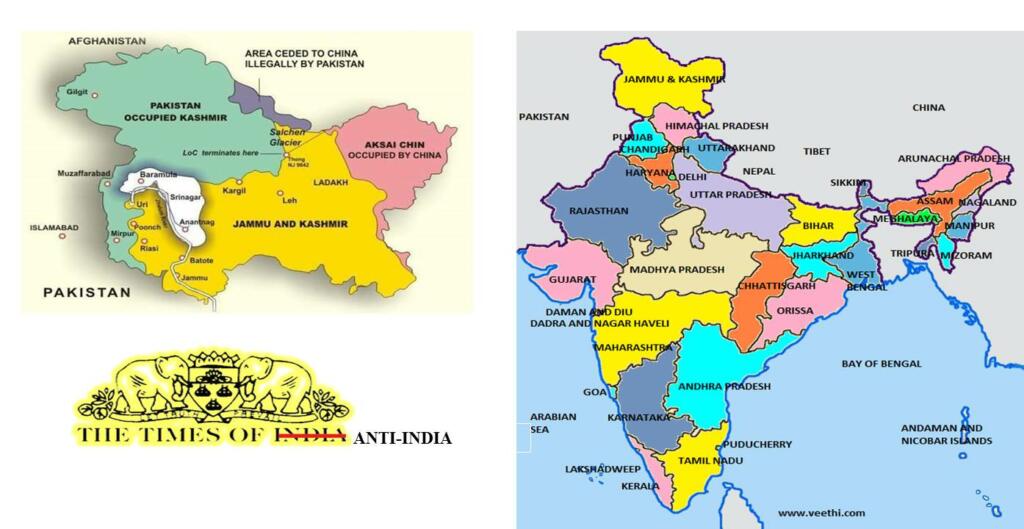
‘Times of India’ goes anti-India
On 4th April, the popular English daily Times of India shared a wrong map where it had given away the illegally occupied PoK to Pakistan. The image was published in an article that dealt with the economic and strategic crisis Pakistan is going through.
In the article, the current scenario of the neighboring country was explained that featured a caricature depicting the image of Pakistan which has a significant portion of Jammu and Kashmir, and Ladakh.
This was pointed out by netizens after the Times group shared the article on the microblogging site Twitter. Netizens vocally condemned the Times of India’s act of tweeting an image of Pakistan’s map that comprises integral parts of Indian territory.
Times of India has neither deleted its tweet containing a contentious image, nor has it apologized for the same. Well, not to mention it is not one of the incidents.
Not the first time by Times of India
This is not the very first time that the Times of India is facing backlash due to its move. As extensively reported by TFI, TOI has a habit of doing so, creating uproars and not learning from them.
In a report published in 2018, the Times of India was hellbent on maligning the Hindus. In an alleged incident of “Godman forcing men into unnatural sex”, TOI used a graphic representation of a Hindu Sadhu as ‘Godman’ when the accused has the name- ‘Asif Noori’. This move of TOI to present Hindus as rapists, impersonators, and homophobic attracted a lot of backlashes.
Read More- Times of India has made it a habit to malign Hindus and the time has come to do something about it
In another incident Times of India dragged Veda Pathshalas even as an incident of child trafficking took place in a Madrasa. Not only this, but the Times of India has also made its anti-India stand public by writing an insidious headline about the dastardly terrorist attack on a CRPF convoy in Pulwama.
Times of India is not the sole platform to get map of India wrong
Times of India is guilty of many things and has faced backlash all time and again. But TOI is not the only group/platform that is to be blamed when it comes to not getting map of India correctly.
Many other media giants especially the Lutyens’ are guilty of the same blunder. In the past, India Today, CNN, Google, and Twitter have made similar blunders by showing distorted maps of India.
In April 2020, India Today presented a graphic containing a distorted map of India during a show hosted by Rajdeep Sardesai. While in December 2020, Today group’s Aaj Tak showed a distorted map on a show based on Bharat Bandh. Whereas in 2021 BBC streamed the wrong map of India while covering the delta variant.
Google has too faced backlash for showing both PoK and Aksai Chin as separate entities and not a part of India, and Twitter is a repeat offender in this context.
But the main question arises, why are these incidents so frequent and how do they get away with this.
Read More- Twitter lands in more trouble by showing J&K as a separate country and Ladakh as a part of China
Depicting distorted map: Not a crime
In the aftermath of the Pathankot terror attack, there were discussions about the Geospatial Information Regulation Bill. While some criticized it, some advocated for the need for its implementation. The move of presenting the bill was also induced by the contentious move of Twitter that showed Jammu and Kashmir and Arunachal Pradesh as parts of Pakistan and China respectively.
The bill advocated that no person shall depict, disseminate, publish or distribute any wrong or false topographic information of India including international boundaries through internet platforms or online services or in any electronic or physical form.
Read More- Congress uses a distorted map of India to express ‘solidarity’ with farmers
However, the bill was shelved for being ‘restrictive’, and guidelines were formulated for acquiring and producing Geospatial data in February 2021, after almost five years since its introduction.
This bill suggested provisions like a prison term of 7 years and a penalty of Rs. 100 crores for the wrong depiction of the Indian map. However, as it has been shoved into cold storage law enforcement agencies continue booking such violations under the existing sections of IPC and the Information Technology Act.
The hard point to understand is what is more important, geography lessons to these news agencies or stringent laws.