
India’s defense minister has warned Pakistan that any misadventure in the Sir Creek sector would evoke a “strong” response from Delhi.
India’s Defense Minister Rajnath Singh warned Pakistan last week against launching any aggression in the Sir Creek sector as it would lead to an Indian response “so strong it would change both history and geography” of the area. In his speech at the Bhuj military base in Gujarat, which borders Pakistan, Singh drew attention to Pakistan’s military build-up in areas adjacent to Sir Creek, a disputed marshland separating India from Pakistan.
“In 1965, Indian Army showed courage by reaching Lahore … In 2025, Pakistan must remember that the road to Karachi also passes through the Creek,” Singh said.
The India-Pakistan War of 1965 began with Pakistan pushing troops into the Rann of Kutch region (where Sir Creek is located). The two sides fought pitched battles here. With Pakistan expanding the war into Jammu and Kashmir, India retaliated by sending its troops across the International Border into Pakistani Punjab. The Indian Army went on an offensive against Lahore from three sides, culminating in their advance to the outskirts of the city.
By drawing a parallel between Lahore and Karachi, Singh indicated that any adventurism on the part of the Pakistani military at Sir Creek could see India hit back at Karachi.
Singh’s warning came almost five months after the three-day war between India and Pakistan in May 2025. Following the terrorist attack at Pahalgam in Jammu and Kashmir on April 22, India launched military strikes on terrorist camps in Pakistan and Pakistan-occupied Kashmir on the night of May 6-7. Singh said Pakistan tried to break through India’s defenses along the Line of Control and International Border stretching from Leh to Sir Creek.
Although hostilities ended on May 10, tension between India and Pakistan remains high.
In the months since the May military clashes, Pakistan’s military build-up in the Sir Creek area has expanded. According to “top intelligence and naval sources” cited in Indian media reports, “Pakistan is establishing military complexes, mini-military cantonments and emergency airstrips in Sir Creek.”
On its side, India already has multilayered security, “with the Border Security Force, the Indian Army, the Indian Coast Guard and the Indian Air Force maintaining a strong presence” in place.
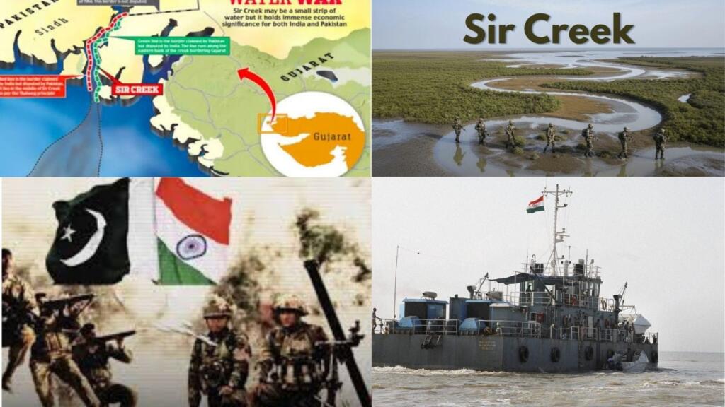
A 96-km-long tidal estuary flowing into the Arabian Sea, Sir Creek separates the Rann of Kutch in India’s Gujarat state from Pakistan’s Sindh Province. The dispute over where the boundary runs in the area can be traced back to the early 20th century, when Sindh was part of the Bombay Presidency and came under British colonial control, while the Rann of Kutch fell under the Princely State of Kutch. The conflict is said to have first erupted between the two principalities in 1908 over a pile of firewood lying on the banks of the creek. In 1914, the Bombay state government “resolved the dispute,” supported by maps. During Partition, Kutch became a part of India, while Sindh Province went to Pakistan.
The 1925 map and the Thalweg principle is clear that the boundary line runs through the middle of the creek. According to the Thalweg principle, where a boundary line involves a navigable waterway, the boundary will run through its middle. Pakistan argues that this principle does not apply to Sir Creek, maintaining that it is marshland and not navigable. India points out that Sir Creek becomes navigable during high tide, and hence the Thalweg principle applies to it.
Where the International Boundary runs at Sir Creek will impact the delimitation of the Exclusive Economic Zones of India and Pakistan in the Arabian Sea. These waters are said to hold hydrocarbons and are rich fishing grounds that support the livelihoods of thousands of people.
The dispute over Sir Creek has been more or less dormant over the decades. However, the creek has witnessed flare-ups, as in 1965, when the area saw fierce fighting. Then in August 1999, amid serious tensions in the aftermath of the Kargil War a month earlier, tensions escalated when an Indian Air Force MiG-21 shot down a Pakistani surveillance aircraft over Sir Creek. The two sides “raced to beef up their defenses in the area thereafter.
The November 2008 terror attacks in Mumbai had a Sir Creek connection. The 10 terrorists who carried out the attacks had captured an Indian boaat in the creek waters to infiltrate Indian territory. The incident underscored how Sir Creek’s location makes it an ideal site for terrorists and drug cartels to operate.
Discussions on Sir Creek and other disputes as part of the comprehensive bilateral dialogue ran aground in 2016 after the terrorist attack at Pathankot. Bilateral relations have deteriorated since, leaving little scope for dialogue to settle disputes like Sir Creek.
Should hostilities erupt over Sir Creek, “ground troops of both sides would find themselves battling a very difficult physical terrain, that this is marshland that is infested with Russel vipers and scorpions. At the best of times, the area is hard to operate in.
Sir Creek is located just 200 km from Karachi, Pakistan’s commercial capital and port city, and PNS Qasim, a key naval base. On the Indian side, several of India’s largest ports, including Kandla Port, Mundra Port, and Mandvi Port, are located in the Gulf of Kutch.