


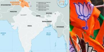


In yet another instance of political misfire, the Congress party has come under renewed fire for using a distorted map of India this time by its Tamil Nadu unit. The controversy erupted when the Tamil Nadu Congress Research Department released promotional content for its campaign titled “100 Days, 100 Places,” aimed at criticizing the BJP government ahead of the 2026 Assembly elections. The cover of the campaign book shocked observers by depicting Pakistan-Occupied Kashmir (PoK) as part of Pakistan and Aksai Chin within Chinese territory. What followed was a barrage of criticism from the Bharatiya Janata Party (BJP) and others, with many branding it a gross insult to India’s territorial sovereignty.
A ‘Sinister and Deranged’ Pattern: BJP Reacts Sharply
The BJP wasted no time in mounting a fierce counterattack. Amit Malviya, head of the BJP’s IT Department, called out the Congress, stating, “There is something truly sinister and deranged about the Congress Party. Despite repeated public outrage and national shame, Congress continues to deliberately use distorted maps of India that cede parts of Jammu & Kashmir to China and Pakistan.”
He continued, “This is not a mistake. It is a premeditated political position. The Tamil Nadu Congress has followed the same anti-national pattern. A distorted and misleading map of India was shamelessly used to promote a party campaign on one of its official X handles.”
Malviya’s remarks encapsulated the mood within the BJP: that this incident wasn’t an isolated case, but rather part of a recurring pattern by the Congress that flirts with anti-national messaging.
There is something truly sinister and deranged about the Congress Party.
Despite repeated public outrage and national shame, Congress continues to deliberately use distorted maps of India — maps that cede parts of Jammu & Kashmir to China and Pakistan.
This isn’t an isolated… https://t.co/Qb4A6sN5O0 pic.twitter.com/YDGRWajpz6
— Amit Malviya (@amitmalviya) June 28, 2025
The Campaign That Sparked It All
The Tamil Nadu Congress Research Department recently launched a political initiative titled “100Days 100Places” meant to showcase what it calls the failures of the BJP-led Union government. The campaign was flagged off at an event attended by senior leader and former Lok Sabha MP Dr. A Chellakumar.
Alongside the campaign was the release of a book titled “Jumla Government’s False Facts and Realities.” What stood out, however, wasn’t the book’s content but its cover, which featured a map of India that included PoK as part of Pakistan and Aksai Chin as Chinese territory.
The post promoting the campaign on social media quickly went viral not for the reasons the Congress may have hoped, but for the glaring cartographic blunder. The backlash was swift and severe.
A History of Cartographic Controversies
Unfortunately for the Congress, this isn’t the first time it has faced similar criticism. Just days earlier, on 18 June 2025, the party’s official social media handle had shared a post criticizing Prime Minister Narendra Modi’s foreign policy. That post, too, included a map of India that showed PoK as part of Pakistan. After facing widespread outrage, the party quietly deleted the post without issuing any clarification or apology.
Even before that, the Karnataka Congress had drawn similar criticism in December 2024, during preparations for the centenary celebration of the 1924 Congress session. Yet again, the party was accused of using a map that did not reflect India’s officially recognized borders.
Each incident has added fuel to the fire, creating a perception that either the Congress is alarmingly careless with national symbols or it is deliberately testing the waters with provocative messaging.
Fallout and Political Optics
With the Tamil Nadu Assembly elections slated for 2026, the timing of this controversy could not be worse for the Congress. The BJP has used the opportunity to question the Congress’s nationalistic credentials and its sensitivity toward India’s sovereignty.
Observers believe this controversy could dent Congress’s image further in a state where the BJP is looking to make electoral inroads. The incident has also given fresh ammo to nationalist groups and social media influencers, who are calling for a public apology and stricter scrutiny of political campaign material.
While the Tamil Nadu Congress has not responded publicly or issued an apology, the silence is being interpreted by critics as tacit approval of the distorted map something that could hurt the party’s credibility in a climate where national identity is a sensitive and mobilizing issue.
Blunder or Intent?
The Congress party’s repeated errors involving India’s territorial map are fast becoming a political liability. Whether it’s negligence or ideological posturing, the implications are serious. Territorial integrity is not just a legal or diplomatic matter it’s a deeply emotional and political one in India. Any political party that tampers with it, even unintentionally, risks alienating a broad section of the electorate.
As things stand, the Congress needs to make a choice: take corrective steps and uphold the dignity of national symbols or continue on a path that gives its rivals easy victories in the court of public opinion. The ball, clearly, is in their court.