
In a remarkable collaboration, the Indian Space Research Organisation (ISRO) has joined forces with NASA to create an unprecedented map of the submerged Ramsetu. This project marks a significant milestone in underwater cartography, offering new insights into this ancient structure. The Ramsetu, a subject of both scientific inquiry and cultural significance, has long fascinated researchers and the public alike.
The Ramsetu Mapping Initiative
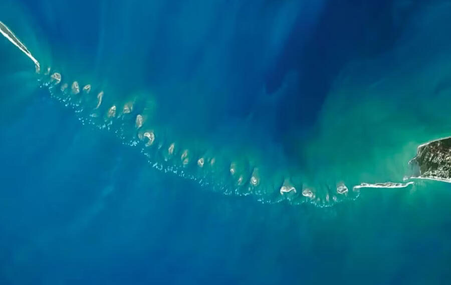
ISRO scientists, in partnership with NASA’s ICESat-2 satellite, have produced a highly detailed map of Ramsetu. This pioneering effort has resulted in a 10-metre resolution map, a first for any undersea structure. The map, spanning 29 metres in length and rising 8 metres above the seabed, is based on data gathered over six years. This extensive period of data collection ensures the accuracy and comprehensiveness of the Ramsetu map.
Cutting-Edge Technology Behind Ramsetu Mapping
Advanced Laser Technology
ISRO researchers used state-of-the-art laser technology from NASA’s satellite to develop this intricate map of Ramsetu. The team, led by Giribabu Dandabathula, employed water-penetrating photons from ICESat-2 to capture detailed information about Ramsetu’s structure. This innovative approach allowed scientists to peer beneath the waves and reveal the hidden contours of Ramsetu.
3-D Analysis
The scientists applied 3-D-derived parameters, including contours, slope analysis, and volumetrics, to determine Ramsetu’s current physical characteristics. This approach provided a comprehensive understanding of the underwater ridge’s composition. By utilizing these advanced techniques, researchers were able to create a virtual model of Ramsetu, offering unprecedented insights into its structure.
Key Findings of the Ramsetu Study
1. Underwater Channels
The research team discovered 11 narrow channels within Ramsetu, each 2-3 metres deep. These channels allow water to flow between the Gulf of Mannar and Palk Strait, revealing the structure’s complex hydrology. The presence of these channels suggests that Ramsetu plays a crucial role in the region’s marine ecosystem.
2. Limestone Composition
The underwater ridge that forms Ramsetu consists of a chain of limestone shoals. This geological information sheds light on the bridge’s formation and endurance over time. The limestone composition of Ramsetu offers clues about the environmental conditions that existed when the structure was formed.
Significance of the Ramsetu Mapping Project
Scientific Advancements
The successful mapping of Ramsetu demonstrates the potential of satellite technology in underwater exploration. This project paves the way for similar studies of other submerged structures around the world. The techniques developed for mapping Ramsetu could be applied to investigate other underwater formations, expanding our knowledge of marine geology.
Environmental Implications
Understanding the structure of Ramsetu is crucial for assessing its impact on local marine life and ocean currents. The detailed map can help scientists study how Ramsetu influences water flow and sediment transport in the region. This information is vital for conservation efforts and marine resource management in the area surrounding Ramsetu.
Historical Significance of Ramsetu
Cultural Importance
Ramsetu, also known as Adam’s Bridge, holds great cultural significance as it is mentioned in the ancient Indian epic, the Ramayana. This underwater bridge connects Dhanushkodi in India to Talaimannar Island in Sri Lanka. The cultural importance of Ramsetu extends beyond its physical structure, as it represents a tangible link to ancient mythology and history.
Historical References
Throughout history, Ramsetu has been known by various names. Until the 9th century AD, Persians referred to it as ‘Sethu Bandhai’. Temple records in Rameswaram suggest that the bridge remained above sea level until 1480 when a storm caused significant damage. These historical references provide a timeline for understanding the changes Ramsetu has undergone over centuries.
Future Research on Ramsetu
The detailed mapping of Ramsetu opens up new avenues for further research. Scientists plan to conduct more in-depth studies of the structure’s geology, investigating how it was formed and how it has changed over time. Additionally, researchers are interested in exploring the marine life that inhabits the area around Ramsetu, as the structure likely serves as an important habitat for various species.
Conclusion
The ISRO-NASA collaboration has produced a groundbreaking map of Ramsetu, offering unprecedented insights into this ancient structure. This research not only advances our understanding of underwater cartography but also provides valuable information about Ramsetu’s geological composition and historical significance. As scientists continue to study this remarkable formation, we can expect to uncover more secrets hidden beneath the waves of this culturally important site. The Ramsetu mapping project serves as a testament to the power of international scientific collaboration and the ongoing quest to understand our planet’s geological wonders.
ALSO READ: Bengal By-Elections: Time for Extensive Reforms in BJP’s State Unit