China’s map: Change is constant, even for nations. Maybe one day we can even see Pakistan actually becoming democratic and secular. Yet, China altering its sly ways seems unlikely.
Days before the G20 summit in India, China did something not entirely unexpected from them. On August 28th, it unveiled a new map, sparking concern. This map claimed Indian areas like Arunachal Pradesh and Ladakh as China’s own. But that’s not all; China also marked Taiwan and the disputed South China Sea territory.
China’s map move is raising eyebrows globally, shedding light on its ambitions. Just as Pakistan’s transformation hints at shifts, this map shake-up reveals China’s intentions, making us rethink geopolitics.
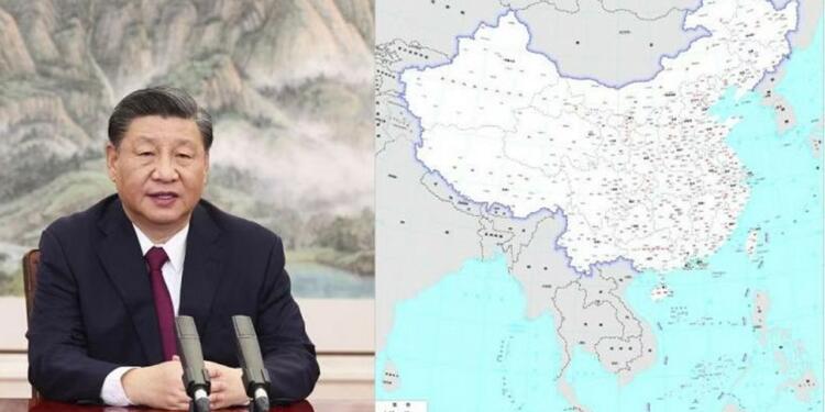
On August 28th, the Ministry of Natural Resources in China made a significant move, launching the country’s latest ‘standard map.’ This event, as reported by The Global Times, the Chinese government’s voice, unveiled a cartographic representation that has sent ripples across the globe. According to this publication, the map compilation was a culmination of national borders from China and numerous other countries, reflecting a vast scope.
However, the implications go beyond mere cartography. The map, as shared by The Global Times, included bold assertions that instantly caught attention. Notably, Indian territories like Arunachal Pradesh and Aksai Chin appeared as part of China’s territorial claim. This visual power play was further heightened by the inclusion of Taiwan within China’s territorial grasp, and a sprawling assertion over the South China Sea, meticulously illustrated through the contentious nine-dash line.
Also read: The expansion of BRICS is official!
This amalgamation of territories under the Chinese banner aligns with the vision of Chinese President Xi Jinping, a strategic move with global ramifications. It’s important to note that these proclamations don’t stand uncontested. Countries like Vietnam, the Philippines, Malaysia, Brunei, and Taiwan have their own competing claims in the South China Sea. The result is a complex geopolitical web, where boundaries on paper clash with the stark realities of sovereignty.
A prime focal point of this map’s audacious claims remains India’s territories. China’s bold move of considering Arunachal Pradesh and Aksai Chin as its own directly opposes India’s stance. India has consistently reiterated that Arunachal Pradesh is, and always will be, an integral and non-negotiable part of its nation. However, China’s perspective diverges, reflecting an imperial hangover reminiscent of past eras.
In the backdrop of this territorial tussle, the timing of China’s map reveal is striking. Just days before the G20 Summit, where global leaders convene, this belligerent assertion displays a lack of sincerity on China’s part in resolving the tensions that linger at the Line of Actual Control (LAC). The world watches closely as diplomatic discourse contends with territorial ambitions, and actions speak louder than words.
In sum, China’s unveiling of its ‘standard map’ extends far beyond a routine cartographic update. It’s a strategic proclamation, visualizing the nation’s ambitions and challenging existing geopolitical norms. The map not only redraws borders but redraws lines of contention and concern, putting into stark contrast the diverse claims over territories and the stark realities on the ground.
Support TFI:
Support us to strengthen the ‘Right’ ideology of cultural nationalism by purchasing the best quality garments from TFI-STORE.COM


