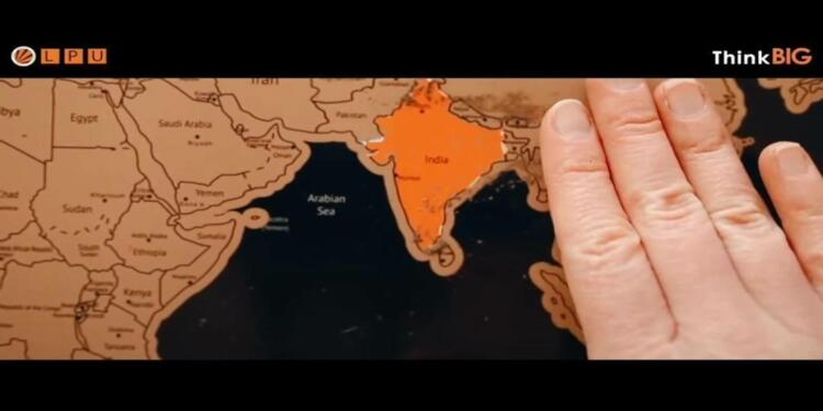
India that is Bharat is not a nation-state. It has its own history and culture. Sadly, the geography encompassing Bharatvash is currently stuck in a world order in which it is tough to demarcate original boundaries. Even then, people and companies claiming to work for the betterment of India do not even know the full details of the original map of India.
LPU shows the wrong map of India
Map of India is again in news. Once again it has been misrepresented to more than 7 billion people all around the globe. And once again a private entity has done it. Adding insult to injury, you will be ashamed to know that a University that has the privileged responsibility of passing on the knowledge has done it.
Recently, Lovely Professional University released a video intended to bring foreign students under its fold. It showed an African guy stating how good LPU is for foreign nations. One of the graphics intended to beautify the video was India’s map. But, that ended up killing the spirit of the video as well as antagonise the nation loving Indians.
Here is the full video posted on 7th june pic.twitter.com/XKtV8HQvXz
— Chad Infi𓄿 (@chad_infi) June 19, 2022
In the map which LPU showcased to be representative of Indian landmass, it had totally cut off Kashmir and Northeast from the region. Sadly, whole world saw it and the message sent out was that India has accepted respective claims of Pakistan and China on Kashmir and Northeast respectively.
Where is Kashmir? @lpuuniversity
And the most amazing thing is that the chancellor of the university is AAPiya. pic.twitter.com/qHCu4BzGnR
— Chad Infi𓄿 (@chad_infi) June 19, 2022
Private companies, Universities and Politicans-Everyone does it
This is not the first time any University or any institution has done this kind of distortion. Recently, a student named Rishi Tiwari was suspended from Azim Premji University on various charges. Apparently, one of the reasons he had become a bone of contention for the authorities of his University was that he used to oppose cutting out Akshai Chin and POK from India’s map.
Similarly, Alumni Section of the Chandigarh University also published a map showing POK as a part of Pakistan. After netizens registered their opposition, the University was forced to remove whole Alumni Section from the website. But, the damage was done.
Hey @Chandigarh_uni, don't you consider POK a part of India ? pic.twitter.com/wVOws5Phv7
— root3vil (@root3vil) June 15, 2022
Dear @PunjabPoliceInd: Kindly initiate legal action against @Chandigarh_uni for putting incomplete map of India 🇮🇳 on their website and showing parts of Ladakh and Kashmir in Pakistan 🇵🇰 pic.twitter.com/aoW0mXVX7I
— Shashank Shekhar Jha (@shashank_ssj) June 15, 2022
If you think, Universities are the only one doing it, then you are wrong. Even Companies like Twitter and supranational organisations like WHO have also done it in the past. The phenomenon was fuelled by non-other than Mr Rahul Gandhi. In one tweet, he had sent a message to China that India had accepted its suzerainty on its territory.
The actual map of India
Now, we do not know whether these acts are done with malafide intentions to grab eyeballs, or they are done in connivance with anti-national forces. Another reason behind the depiction of wrong map of India could be that these institutions and politicians do not actually know India’s length and breadth. Here are the details.
India’s official map is published by Survey of India. It is India’s central engineering agency in charge of mapping and surveying. It works under the ambit of Ministry of Science and Technology. Army Officers from Indian Army Corps of Engineers and Civil Services work in unison to determine India’s actual map.
Body mind and soul of India
Current Indian map is available on its website. For your convenience, we are showcasing it here. Watch the upper north part of our map. The area which is Pakistan Occupied Kashmir for the rest of the world is under India’s territorial jurisdiction. Then, head towards the Akshai-Chin portion which China loves to call as its own territory. This portion is also an integral part of India. We hope you do not have any doubt over Arunachal Pradesh and other NorthEastern states being a part of India. Similarly, Nepal’s claim on Lipulekh and Kalapani is also bogus as India administers all those territories.
For the last time, look closely at this map and memorise every portion in your head. Akshai Chin, POK, Lipulekh, Kalapani, Arunachal and other NorthEastern states are all parts of India. There is no doubt over it.
To sum it all, current Indian geography accepted by rest of the world is our body. Akhand Bharat is our mind and riding on the principle of Vasudhaiv Kutumbakam and Veer Bhogya Vasundhra, whole world is our soul.
Support TFI:
Support us to strengthen the ‘Right’ ideology of cultural nationalism by purchasing the best quality garments from TFI-STORE.COM.


