

China keeps trying to backstab India in Eastern Ladakh, while the Indian Army has been adroitly mirroring all Chinese build-ups and mobilisations. Merely days after the Corps-Commander level meeting between the Indian Army and the Chinese People’s Liberation Army (PLA), India Today has reported that China is trying to open a fresh front against India in Eastern Ladakh- the Depsang Plains.
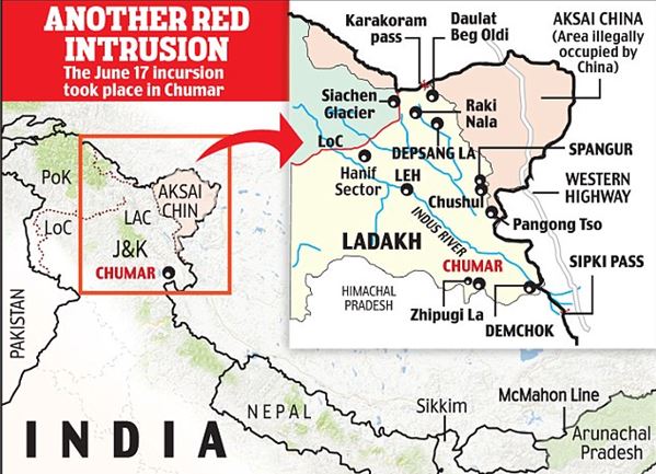
Depsang Plains, known in military circles as Sub-sector North (SSN) is strategically crucial as it lies to the South of Daulat Beg Oldi (DBO). According to India Today, sources have confirmed Chinese build-up east of DBO.
New Chinese tracks and camps have come up only this month, and it has been confirmed by tracking movement on the ground. But the Indian Army hasn’t been caught napping as the Chinese moves had been predicted early on and the Indian Army started mobilising in this part of Ladakh in late-May itself.

The Depsang Plains are traditionally susceptible to confrontations between India and China. During the 1962 Sino-India war, the PLA had occupied the whole of Depsang Plains. Then in 2013, there was a three-weeks long stand-off after the Chinese troops intruded and set up positions 19 kilometres inside the Indian territory.
Depsang Plains are always a cause of concern, as it is the only part of Ladakh that offers ease of access and some measure of manoeuvrability. If China tries to bring in light armoured vehicles into the picture, it will open up the Depsang Plains.
Meanwhile, there are also reports of movement in Patrolling Point 14 (PP-14), the same point near which a violent face-off happened on June 15 resulting in 20 casualties on India’s side and far more deaths on China’s side.
Movements in Galwan PP14. Will update details shortly. Also expect updates from me on Pangong & Depsang sectors today. Meanwhile, @detresfa_ has just put out June 22 (day of Lt Gen meet) sat image of site of June 15 clash. #IndiaChinaFaceOff pic.twitter.com/nihj2PFxCj
— Shiv Aroor (@ShivAroor) June 24, 2020
With this, China seems to be trying to open up the Galwan Valley region all over again. Apart from military manoeuvres on the ground, what the Chinese Foreign Ministry is saying is particularly objectionable.
The Galwan Valley starts at the confluence of the Galwan and Shyok rivers, known as ‘Estuary’ among the Chinese and Y-junction in the Indian military circles. The Chinese claim line and the LAC correspond to each other in the Galwan Valley.
For years, the LAC that both sides have been observing is to the East of the Galwan-Shyok confluence. Patrolling Points- 14, 15 and 17 are located in this area on India’s side of the LAC.
However, China is now claiming sovereignty over the entire Galwan Valley, a claim which is wholly untenable and opposed to the status quo.
The Chinese Foreign Ministry spokesperson Zhao Lijian even alleged, “It is the Indian side that went against the bilateral agreement. The Indian side at first agreed to withdraw personnel from Galwan Valley which it did, and it dismantled its facilities as requested by the Chinese side. During the first Commander meeting on June 6, the Indian side committed to no trespassing of the Galwan Valley for patrolling and for building. The two sides agreed to set up observatory posts at the two sides of the Galwan river estuary, but the Indian side went against this agreement and asked China to dismantle China’s posts, and also crossed the LAC.”
At the end of the day, China’s actions are pre-meditated and aimed at targeting the Darbuk–Shyok-DBO Road (DSDBO Road) that connects Leh to the Daulat Beg Oldi, the northernmost point in India’s Ladakh territory where India operates the world’s highest airstrip. The road runs on an alignment East of the confluence of Galwan and Shyok Rivers, and also passes through the Depsang Plains that is close to the Karakoram Pass.
With build-up in the DSBDO Road and attempts to push the LAC westwards in the Galwan Valley region, China wants to interdict and cut off India’s access to the Daulat Beg Oldi airstrip, as also the Karakoram Pass.
Moreover, Sub Sector North (SSN) lies east of Siachen glacier, and therefore India will have to be careful of China’s desperate designs to loosen New Delhi’s grip over the highest battlefield in the world.
Finally, SSN is the only area that offers India access to China-occupied Ladakh, which is called Aksai Chin by Beijing. Therefore, China is trying to hamper the 255-km long DSDBO road.