
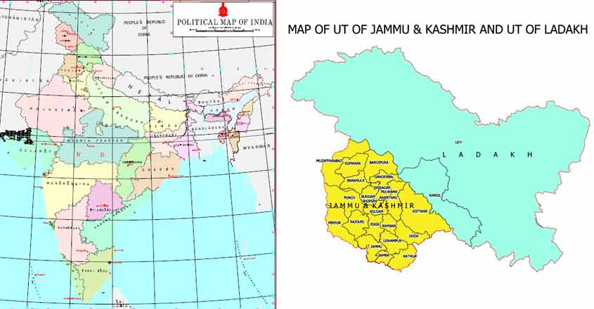
Following the removal of Article 370 and the bifurcation of the state of Jammu & Kashmir into separate Union Territories of Ladakh and Jammu & Kashmir, the Survey General of India has released the new political map of India. The newly-released political map is a strong assertion and reiteration of India’s legitimate territorial claims and geopolitical goals in the region. Ladakh is now the largest Union Territory, with two districts Leh and Kargil.
India gets a new map.
Centre notifies geographical boundaries of newly carved Union Territories of J&K and Ladakh. pic.twitter.com/j49LmOUUID— Vijaita Singh (@vijaita) November 2, 2019
If we take a look at the political map released by the Survey General of India, it fully reinforced India’s main geopolitical goals- Pakistan occupied Kashmir, Gilgit-Baltistan and Aksai Chin. The newly carved out Union Territory of Jammu & Kashmir includes the districts of Muzaffarabad and Mirpur- both of which are currently in the illegal occupation of Pakistan in the form of Pakistan occupied Kashmir. This is in line with India’s recent posture manifesting its ambitions when it comes to changing the status quo vis-a-vis Pakistan occupied Kashmir.
The political map also sends across a much-needed message by including Aksai Chin and Gilgit-Baltistan within the Union Territory of Ladakh. Aksai Chin is a 38,000 sq. km. territory in the Ladakh region of India, which is currently under the illegal occupation of China.
Recently, the Ministry of External Affairs had explicitly stated, “We expect other countries to respect India’s sovereignty and territorial integrity. China continues to be in occupation of a large tract of area in UTs of Jammu & Kashmir and Ladakh. It has illegally acquired Indian territories from PoK under so-called China-Pakistan boundary agreement of 1963.” It is clear that India considers retrieving the territory of Ladakh under Chinese and Pakistani occupation to be a major geostrategic goal and this is clearly manifested by the new political map of India.
MEA: We expect other countries to respect India's sovereignty&territorial integrity.China continues to be in occupation of a large tract of area in UTs of J-K,& Ladakh. It has illegally acquired Indian territories from PoK under so called China-Pakistan boundary agreement of 1963 pic.twitter.com/MVGvmXP7V0
— ANI (@ANI) October 31, 2019
The Union Territory of Ladakh has rightly come to include Gilgit-Baltistan. It is not a part of Jammu & Kashmir, but a part of Ladakh as has been manifested by the new political map. Pakistan administered Gilgit-Baltistan, for almost six decades as an internal colony. Gilgit Baltistan, known then as Northern Areas enjoyed no constitutional protection in Pakistan and was governed directly from Islamabad. In fact, only in 2009, was Gilgit Baltistan legislature set in place and constitutional provisions on judiciary, executive etc., brought in force.
What creates further complications in the non-Sunni majority area of Gilgit-Baltistan in the backdrop of a Sunni-majority Pakistan is the fact that in 1984, Pakistan abolished the State subject rule in Gilgit-Baltistan. Therefore, people from all over Pakistan can purchase property in Gilgit-Baltistan. This was a clear step towards materially altering the demographic composition of the region. Moreover, even though Gilgit-Baltistan was given some autonomy vide a 2009 Order, it was again overridden by the Gilgit-Baltistan Order 2018 that gave Pakistan absolute authority over the region. Currently, Gilgit-Baltistan enjoys only a semi-provincial status.
Reclaiming territory of Ladakh in illegal Chinese and Pakistani occupation can be the most important geopolitical goal in India’s agenda. Its geostrategic importance can be realised only by looking at the political map. It must be noted that traditionally the Union Territory of Ladakh includes Leh, Kargil, Gilgit, Hunza and Skardu. It shares borders with China and Afghanistan and in ancient times, was India’s gateway to central Asia.
Passes of Ladakh connect India to the politically and economically crucial Central Asia region. It is only through this region that India can have easy access to Central Asia given the geographical proximity to Central Asia, given that Tajikistan is merely 20 km away from Ladakh. India has a long history of cultural and commercial links with Central Asia and Ladakh is at the centre of these relations given its geographical proximity to the politically and economically significant region. The events of Pakistan illegally occupying Gilgit-Baltistan, India’s lawful territory and later China occupying Aksai Chin led to disintegration of Ladakh. The occupied territory are de jure parts of India, however the illegal occupation has deprived India of the geostrategic advantage of the region.
India’s new political map is bound to rattle Pakistan and also rile up China, given that Pakistan has been conceding more and more land to China under the CPEC project. China has made significant investments in the region, notwithstanding the fact that the territory has been illegally occupied by Pakistan, and the dragon stands to lose in a big way given India’s legitimate territorial claims in the region.
In fact, China illegally occupies 5,180 kilometres of Indian territory in the form of the Trans-Karokaram Tract, a part of the Hunza-Gilgit region, vide the so-called China-Pakistan boundary agreement of 1963. China has gone on to build the Karakoram Highway which passes through the strategic Gilgit-Baltistan region. However, India has made it clear that China has illegally occupied this territory, which lawfully vests in the Indian Union Territory of Ladakh. The newly released political map has thus made a grand reiteration of India’s lawful territorial claims in the Union Terrorities of Jammu & Kashmir and Ladakh.